Getting to Lauterbrunnen/Grindelwald area:
You need to make the connection at the Interlaken “Ost” station, not Interlaken “west”.
The Lauterbrunnen train (usually on track 2A/B near the station) comes in two sections. One section is marked “Grindelwald” on the cars, the other “Lauterbrunnen” on the cars. The train will separate at Zweilutschinen, so be sure you are in the right car. Trains to Lauterbrunnen/Grindelwald run every half hour, and you can check the exact times here:
The first prices to show on the sbb site assume a half-fare card, so double the price shown if you don’t have one.
If you have time in Interlaken Ost, there is a huge Coop grocery store across the street from the station and it has a reasonably priced buffet restaurant there too.
Note that every train station and cable car station should have a W.C./restroom.
Cable Car tickets:
Cable car & train tickets to the major trails can be pricey, but if you look at it as saving you HUGE amounts of time and energy so you can enjoy the scenery, then it’s easier to take.
Generally you will want the “retour” (return) ticket.
You can keep prices down by doing 4 things:
1) If you have kids under 16, they are totally free on trains and cable cars all over Switzerland if you buy each a Swiss Family Card for about $20. These are available at major train stations.
2) If you are going to be traveling by train or cable car for several days, the Swiss half-fare card is worth it. It is about $130, and good for any Swiss train or cable car for a month. Or, if you are doing more train travel in the area from Bern to Lucerne and south to Italy, consider the Bemer Oberland Pass. https://www.regionalpass-berneroberland.ch/en/
3) If you are going to the Jungfraujoch (“Top of Europe”), you can buy the “Good Morning ticket” (first train up for the day) or “Good Afternoon ticket” (3:30 from Kleine Scheidegg) and save about $35 each.
4) Take the valley train rather than mountain train or cable car. If you are in Lauterbrunnen and want to go to Grindelwald for the day, don’t go up and back over the mountain via Kleine Scheidegg. That would be about $100 RT. If you take the train via Zweilutschinen (change trains there), it is about $12 RT, 35 min each way.
Hiking times:
Weather and Rainy day activities:
-
https://www.meteoblue.com/de/wetter/vorhersage/woche/m%c3%a4nnlichen_schweiz_11487862
-
https://www.maennlichen.ch/en/livecam-245.html
-
https://www.meteoblue.com/de/wetter/vorhersage/woche/first_schweiz_10627547
-
https://panocam.skiline.cc/firstbahn
-
https://www.meteoblue.com/de/wetter/vorhersage/woche/luzern_schweiz_2659811
-
http://www.luzern.com/en/webcam-lucerne
- Hike behind Staubbach Falls at Lauterbrunnen (out of the rain half the time)
- Hike or bus over to Trummelbach Falls (inside the mountain, so out of the rain)
- Visit the Lauterbrunnen Museum (near the river, near the church)
- Take the train to Interlaken Ost station and browse the huge Coop store across the street
- If you have a train pass, check the weather for Luzern, 1.5 hrs away. You can see the current rain, and predict future path with the slider: https://www.meteoswiss.admin.ch/home.html?tab=rain
- Likewise for Bern. With an umbrella you can walk to Einstein’s house and then be out of the rain
- Misty day: train to Meiringen and visit Aareschlucht (Google it)
- Take a boat ride on Lake Brienz, especially if covered by your pass
Prices:
Grindelwald – First 30 (cable cars run continuously)
Grindelwald – Lauterbrunnen 12 (trains every half hour, 15 min wait in Zweilutschinen)
Grindelwald – Grosse Scheidegg bus 15 (about every half hour until suppertime)
Grindelwald – Mannlichen 30 (cable cars run continuously)
Timetables for most of the routes below:
https://schilthorn.ch/en/Infos/Timetable__and__Tariff
Lauterbrunnen – Wengen 8 (trains every 30 min)
Wengen – Mannlichen 24 (cable car about every half hour)
Kleine Scheidegg – Wengen 16 (trains every 1/2 hr)
Wengernalp – Wengen 10 (1/2 hr)
Lauterbrunnen – Trummelbach bus 4 (1/2 hr)
Lauterbrunnen – Grutschalp 8 (1/2 hr)
Grutschalp – Murren 8 (1/2 hr)
Murren – Allmendhubel 9 (1/2 hr)
Murren – Stechelberg 12 (1/2 hr)
Murren – Schilthorn roundtrip 82 (1/2 hr)
Interlaken Ost – Jungfraujoch roundtrip 200 (1/2 hr)
Interlaken Ost – Lauterbrunnen 12 (1/2 hr)
Wilderswil – Schynige Platte 32 (1/2 hr)
Restrooms:
If you have children or are past a certain age, you may find yourself thinking about where the nearest restroom is during a hike. Every train station and cable car station should have restrooms. Sometimes they are near the station: approaching Grindelwald, they are to the left of the train tracks, at Lauterbrunnen, they are behind the train station and under the street.
If you are walking the Lauterbrunnen valley, there are also restrooms at Camping Jungfrau, next to the camp store (buy something to show appreciation). Also some at Trummelbach Falls, even if you don’t enter the Falls. Last time we were at the Falls, the signs said “Herren/Damen”, and it was fun to sit and watch about 1 in 20 tourists go in the wrong one.
There are also pit toilets at the following locations: Spielbodenalp, Schiltalp, Bachalpsee, and at the half-way Berghaus on the Schynige Platte to First hike.
Other hikes to consider:
If you’ve done the other dozen hikes around Murren, Lauterbrunnen, Grindelwald, etc., then here are some more excursions to consider.
Harder Kulm. Cross the river via a bridge near the Interlaken Ost train station, and take the funicular up to Harder Kulm (or “Heidi Klum”, as I’ve heard it called) for a short walk to a great view of the Berner Oberland. https://www.jungfrau.ch/en-gb/harder-kulm/
Aareschlucht. Take the train to Meiringen then take this boardwalk through a deep river ravine. https://www.aareschlucht.ch/en/welcome
Reichenbach Falls. If you are in Meiringen, you can also consider Reichenbach Falls, where the fictional Sherlock Holmes met his “death”. You can also hike above the falls through interesting ravines and even walk to Rosenlaui where you can catch a bus over to Grindelwald. https://www.world-of-waterfalls.com/europe-reichenbach-falls.html
Lobhornhutte. Look at this map to find this Swiss mountain hut on the far right: http://www.gimmelwald.com/pics/gimmelwald/hikemap.jpg
You can take a bus from Lauterbrunnen to Isenfluh, take the cable car up to Sulwald, hike uphill through Chuebodmi and up to the Lobhornhutte. If you walk further uphill, there is a nice overlook where you can look out over Saxeten towards Interlaken and beyond. You can stay at the Lobhornhutte, reserve here: https://www.lobhornhuette.ch
Otherwise, you can return to Lauterbrunnen the same day. Take a right at Chuebodmi towards Sauslager in the beautiful Saustal valley, and then continue on to Grutschalp where you can catch the cable car down to Lauterbrunnen. Takes perhaps 7 hours roundtrip.
Gaulihutte. Take the train or car to Innertkirchen, which is very close to Aareschlucht, above. Check in at the Tourist Info there so they can let Gaulihutte know you are coming. (They’ll search for you if you don’t show up!) If you have a car you can drive southwest from Innertkirchen past Unterstock to Urbachtal Parkplatz to save about a mile off the hike. The trail itself forks twice, take a left each time to take the lower route which passes by Mattenalpsee, which is a water reservoir. Takes about 5-6 hours one way, so you’ll want to stay at the hut overnight. You can get a good overview of the terrain by watching this family’s video of their hike: https://www.youtube.com/watch?v=SVFfCPajVAM
There are a couple of short sections that might make some nervous. You have to hold on to a chain while traversing a steeper slope. But that family above made it out alive!
You can see the trail map if you zoom in on Innertkirchen & south on this topo map of Switzerland: https://map.schweizmobil.ch/?lang=en
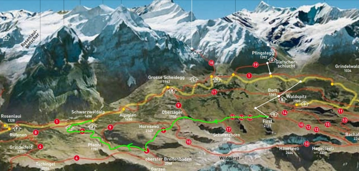
Hornseeli. Take the First to Grosse Scheidegg hike, described as G2 under Grindelwald hikes on this site, but 3/4ths of the way to Grosse Scheidegg the trail forks and you’ll take a left while the main trail goes right towards at Grosse Scheidegg. You’ll be heading toward Scheidegg Oberlager (topo map above is helpful). After passing Oberlager, you’ll head diagonally up the slope to the little lake Hornseeli, pass by it, and down the other side, where you’ll follow a stream and trail downhill, eventually ending up at Schwarzwaldalp where you can take a bus (before 6pm) back to Grindelwald. The mountains behind Schwarzwaldalp are very interesting, looking a bit like the Italian Dolomites. Trail in green, map courtesy of http://rosenlaui.ch/cmsfiles/wanderkarte_rosenlaui.pdf
Maps of Jungfrau areas:


The above “Tips” info in a pdf file so you can print it out or put on phone for offline use:
